‘ALFA’ Locations of interest
Posted: May 19, 2013 Filed under: Uncategorized Leave a commentwhere
- Upper Severn
- Pickering Beck
- River Elwy (awaiting some permissions)
- River Irwell
- River Brit
are surveyed and opportunities exist for
Attenuation modelling of Landuse, Flood Alleviation, green storage and lower (peak) stage.
* * * * * * * * *
![]()
Hybrid grass ‘could reduce flooding impact’
Posted: April 20, 2013 Filed under: Uncategorized Leave a commentMark Kinver, BBC News Environment reporter, writes:-
“A hybrid farmland grass, developed by a team of UK researchers, could help reduce flooding, a study has shown. A team of plant and soil scientists said tests showed the new cultivar reduced run-off by 51%, compared with a variety widely used to feed livestock. They added that rapid growth and well developed root systems meant that more moisture was retained within the soil rather than running into river systems.
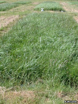
High Friction Grass – photo courtesy Dr Kit McCleod, James Hutton Institute
The novel grass is a hybrid of perennial ryegrass (Lollium perenne) – which is widely planted by farmers for grazing livestock – and meadow fescue (Festuca pratensis), which has environmental stress-resistant characteristics.
Co-author Kit Macleod, senior research scientist at the James Hutton Institute based in Aberdeen, said a long-term project had been developing novel forage grasses but their environmental benefits had not really been tested.”
More on greener grass (courtesy BBC online) http://www.bbc.co.uk/news/science-environment-22307863
The findings appear in the journal Scientific Reports.
![]()
Upper Severn 2D Model
Posted: December 10, 2012 Filed under: Uncategorized Leave a comment
Click here for the presentation slides of the 2011 numerical analysis
High Friction infrastructure failure
Posted: December 5, 2012 Filed under: All Rivers | Tags: attenuation, Elwy, flood Leave a comment
Click image for link to gallery
Porous infrastructure failure at SH2937
![]()
Menu Development
Posted: January 20, 2012 Filed under: All Rivers | Tags: Geo Leave a commentCatchments
- Istwyth, Severn, Irwell, Parrett, Elwy, Pickering, Rye, Ripon. Leam
- Mapping: Gmap, Geotag Gallery, GIScloud
- National catchmen-based approach
Stakeholders and Partners
- PLC’s, LLA’s, Agencies, Insurers
- Conference: River Science, Amenity, Flood Alleviation & Sustainable Engineering.
Science
- Open Generic Method, Open Review, Open Source
- Modelling Utilities: River2D, Anuga, ISIS 1D,
- Templates
Debate
- of issues from Seminars, Networked Groups, National Research Programmes
About
- Atrepo
- Acknowledgement
